"Transmission line buffer corridors or buffer zones are the area below, and around,
transmission lines in which activities and land uses that are incompatible with the safe and
efficient operation of the national electricity transmission network are avoided."
-Sep. 2012, "Q&A: Transmission Line Buffer Corridors", Transpower
-Sep. 2012, "Q&A: Transmission Line Buffer Corridors", Transpower
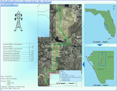
For the GIS4043 Intro to GIS lab final project we were tasked with creating 5 impact maps that assess the following proposed conditions regarding the installation of the Bobwhite Transmission Line, that runs from Manatee county, Florida to Sarasota county, Florida.
-It has relatively few homes in close proximity.
-It generally avoids schools and school sites.
-It avoids large areas of environmentally sensitive lands.
Conservation lands and wetlands.
-It has relatively few homes in close proximity.
-It generally avoids schools and school sites.
-It avoids large areas of environmentally sensitive lands.
Conservation lands and wetlands.
-The line can be
built along this route for a reasonable cost.
The Bobwhite-Manatee Transmission Line Project was completed only after applying multiple skills learned and mastered through study and persistence in Arcmaps. Not only were the 5 presented maps assessed for but also an array of design elements were considered in the construction of this impact report.
This semesters introduction to GIS has proven to be one of the most beneficial and creative expressive classes I've ever taken. I personally have enjoyed learning an array of GIS skills that I plan to carry on with me in to not only future GIS courses but all projects that are environmental science related.
Power Point Presentation - http://students.uwf.edu/atg6/GIS/BWMTLP_powerpoint.pptx
Slide by Slide Script - http://students.uwf.edu/atg6/GIS/BWMTLP_slidebyslide.pdf


