Tuesday, December 11, 2018

GIS 4930 - Project 4 - Navarre Food Desert Analysis

    A food desert can be described as an area in a community that has succumbed to health degradation as a result of no nearby nutritional sources.

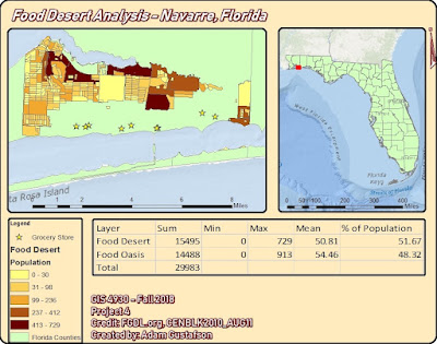
    For the final portion of Project 4 we were tasked with assembling all of our food desert data into one concise power point presentation dedicated to highlighting our food desert area and illustrating how it is effecting the community. I chose my hometown of Navarre, Florida for the study area to my Food Desert Analysis. Navarre is approximately 84.83 square miles in area and 9 grocery stores were identified for this analysis.
GIS programs involved in this analysis included utilizing: ArcMap, Qgis, Leaflet, and Mapbox. Methods involved creating shapefiles for food deserts and grocery stores in Navarre. Shapefiles were uploaded into Mapbox as tilesets and displayed in Leaflet. Arcmap was used to create the study area map. The most challenging technique in this project involved having to create the Navarre food desert shape file. A new Near.csv to reference object id’s within 1 mile and unique to Navarre had to be created along with a new set of centroids.
The data being displayed indicates that grocery stores in Navarre are restricted mainly to highway 98. This restriction creates food deserts the farther north you travel from highway 98. I used my local town and the data does not surprise me. I knew that most grocery stores were located either directly on highway 98 or within at least 1 mile.

Food Desert = 51.67 % of total population
Food Oasis = 48.32 % of total population

    From these results one might conclude that Navarre is suffering from a food desert issue but this is not necessarily true. Yes the majority of land cover in Navarre is designated as food desert but the accessibility of highway 98 needs to be taken into account. All of these grocery stores are located less than a mile from highway 98 the main life line of Navarre. The accessibility of these grocery stores allows for Navarre to not be effected as drastically by food desert areas in regards to health and well being. 

    Navarre is a rapidly growing tourist driven town. There is no way that Navarre is suffering from negative health effects brought upon by inner community food desert intensification. This analysis has revealed that Navarre is majority food desert by total population but the accessibility of grocery stores off sets these food deserts by being located directly on Highway 98, the life line of the Gulf Coast. This analysis has shed light onto areas that can potentially benefit from grocery store construction in Navarre, Florida but like I said before Navarre is not under a food desert threat.



GIS 4035 - Final Project - Estuary Comparison - Sediment Deposition

For the final project of Photo Interpretation and Remote Sensing we were tasked with performing manual or automated image processing techniques on remotely sensed data. The landsat imagery for this project was obtained from USGS.com utilizing their GIS database known as Earth Explorer. The imagery I chose was captured by the Sentinel II satellite. Preprocessing techniques for this project involved clipping, scaling and visualizing the imagery to assess for estuary location, bay shape, water color gradient, and tidal influx/outflux.Programs utilized to perform this analysis included Erdas Imagine and ArcMap. Utilizing Erdas Imagine I was able to perform a supervised classification for the study areas of Pond 6 and Saultsman Cove.
 

Utilizing ArcMap I was able to create the following map deliverable, a combination of two maps showing study area, supervised classification, state extent, and spectral Euclidean distance for the two selected estuaries. An overall dark Euclidean distance output being indicative of pixels that have a higher likelihood of being classified correctly. My map, displayed below, contains not only all deliverable map elements including scale bar, north arrow, study area extent, legends, credit, and author, but also class area and total area derived from tables created and imported from Excel after analyzing attribute table data added in Erdas for each respective study area. In conclusion, I found this project to be an accurate assessment for testing an array of GIS skills related to land use land classification. In performing this sediment deposition analysis I have learned that by analyzing pixel coloration one can determine sediment deposition accurately. Sediment deposition rate was assessed for by analyzing the area values for high, medium, and low sediment classifications for each respective study area, and Pond 6 was found to have a higher chance at silling up the quickest.


Friday, December 7, 2018

GIS 4930 - Project 4 - Analyze 2- Food Deserts

For this weeks portion of project 4 we were asked to create a webmap in leaflet for food deserts in an area of our choosing. I chose Navarre, FL, my hometown as the study area for my food desert analysis.
I obtained my data using www.fgdl.com I searched florida census and downloaded

       2010 U.S. CENSUS BLOCKS IN FLORIDA
CENBLK2010_AUG11
                
The extent of the processing I did involved clipping the data to a shapefile of santa rosa county then selecting for all object ID’s within Navarre in order to create a study area shapefile.
For the grocery store shapefile I used ArcGIS and the coordinate inquiry box in order to zoom to the coordinates of all grocery stores in Navarre. I obtained coordinates using google maps. Once the coordinate inquiry located  a grocery store location I would put a point using the ArcGIS editor on a newly created navarregrocerystores.shp.

The data being displayed indicates that grocery stores in Navarre are restricted mainly to highway 98. This restriction creates food deserts the farther north you travel from highway 98. I used my local town and the data does not surprise me. I knew that most grocery stores were located either directly on highway 98 or within at least 1 mile.

http://students.uwf.edu/atg6/GIS/navarre_fooddesert.html

Spring 2023 semester wrap up

 The spring 2023 semester at UWF has been an eventful one in which I finalized the requirements for my bachelors of science in natural scien...