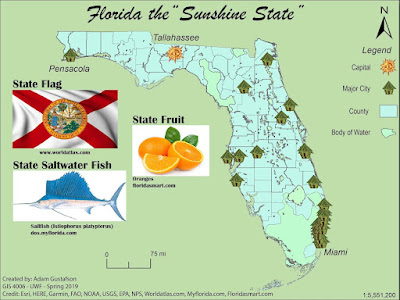
I used scripts in this lab exercise to replace all major cities symbols with the symbol for a primitive hut. I did this by selecting both the major cities object and the hut object from the layers panel and ran the supplied script. I also applied this same method to the capital object in order to replace it with a primitive sun symbol.
I added a 1.0 neatframe by drawing a rectangle and adjusting the stroke width and color. I also added a drop shadow to my counties object by selecting it in the layers panel and then choosing the effect tab > stylize > and drop shadow. I added images of Florida’s state flag, salt water fish, and fruit from the web. A custom north arrow was chosen from ArcGIS symbols and a legend was created with corresponding map symbols and elements.


No comments:
Post a Comment