Understanding that every projection distorts is the key to figuring out which projection you need to use.
In this weeks lab we were tasked with creating multiple shapefiles from a multitude of sources and assembling all of this information into a single .mxd in Arcmaps with a uniform projection. To begin we were introduced to two data storage sites, Labins.org and FGDL.org. These websites specialize in storage and download of Florida mapping files, including but not limited to aerial photography, wildlife distribution, roads, rivers, and a multitude of other files.
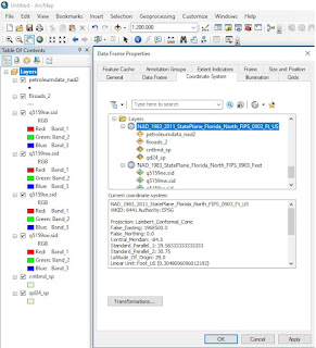
For my final submission I used Labins.org to pull four aerial photography files in raster form (.sid) for quadrant 5159 in Escambia county Florida. These four quadrant files (NE,NW,SE, and SW) were projected as NAD_1983_StatePlane_Florida_North_FIPS_0903_Feet and applied as four seperate layers.
The second layer of my final submission required the use of FGDL.org in order to download a shapefile of Floridas major roads. This data file came projected in Albers Conical Equal Area but through the use of the project(data management) tool the file was reprojected to NAD_1983_2011_StatePlane_Florida_North_FIPS_0903_Ft_US.
The third layer consisted of county boundaries with the above mention state plane projection.
The fourth layer consisted of stateplane quadrants reprojected in the above mentioned state plane projection.
The fifth and final layer involved conversion of an excel data sheet of petroleum storage tank contamination monitoring sites
in Escambia County into a shapefile and imported over the existing layers. For this data sheet to align correctly the given coordinates (in DMS) were converted into decimal degrees and imported into Arcmaps with the WGS_1984 projection then reprojected into the above mentioned state plane projection.
The final result (pictured below) resulted from the understanding of projections, the project(data managment) reprojection tool, and accessing data files in the above mentioned data storage websites.


No comments:
Post a Comment